Signs: standard orange-red, red-striped yellow and red signs "V3". Signs are not on the top part of Navegna and on the way back after the ruins of Mirandella.The route presents difficulties due to the vegetation - including juniper, broom, brambles and wild roses- that tends to cover the trail from the departure point up to Fonte Le Forche. The same situation occurs on the way back, if you choose to descend directly from the ruins of Mirandella: the path is now covered by vegetation in several sections.From the A24 Roma-Aquila, exit at the Carsoli-Tagliacozzo towards Carsoli. Immediately follow the signs for Turania, then those for Lake Turano. At a fork in the road follow the direction for Rieti. Going along the lake, after a while turn right to the road that leads to Ascrea. In the village follow the signs to the police station and park just before this, near a bend on the right (770 m).
|
|
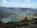
The Lake of the southern slope of Turano Navegna |
The trail begins along the road just at the bend (clear yellow-orange signs on the rock), continues bypassing the gently sloping hill and reaches a junction (902 m)from which going straight following the signs. Shortly after, the trail starts to border the Pit of Valloppio on its ride side, alternating stretches of forest with open patches ,then turns towards to the left and easily crosses the ditch (1028 m). there are no signs for a short distance. Via a steeper and sunny slope you get at Le Forche spring (1140 m). Here, in addition to the fountain, there is a well equipped picnic area on the right . On the left hand, the route goes right under two shepherd refuges, with the addition of red signs "V3". After crossing a stony area with few trees, the trail turns right and suddenly you find the fully panoramic view of the Turano lake and the town of Castel di Tora with the promontory of Monte Antuni lake. At this point (1226 m) indicated by an arrow on a rock, the trail turns right and climbs on top of the Nogaro (1288 m), which offers an even better view of the lake. From here you descend into the woods along a long fence and at some point (1306 m) turn on a steep path on the left (watch out for signs). A little further on, at the last two trees (1366 m), ending the signs and continue along the path trail on the grassy slopes of Costa Cipolla, with a view of the lake on the right and another fence on the left that you approach as you climb. You should cross the fence as soon as you find a breach and continue for the top rake. The cross that marks the peak is visible only when you are just below.
|
|
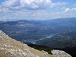
Il lago del Salto dalla vetta del Monte Navegna |
From the summit (1508 m), in addition to the landscape of Turano which accompanied us during the ascent,you can see the other side of Lago del Salto. You recognize many of the characteristics peaks of Lazio and Abruzzo. You can easily spot the slopes of Mount Soratte Turano and the Gran Sasso in the distance on the side of the Salto.
For the return, go back to Le Forche spring. You can take the alternative route that allows you to visit the ruins of the ancient settlement of Mirandella. Just below the picnic area of Le Forche spring, take the wide path for Mirandella, marked by "V4" signs on green posts . After a while, you come to a gate that leads into a fenced area where four paths branch off closer. Following one of the central paths preferably, you reach the ruins after a short (30-40 minutes from the Le Forche spring, 1171 m the highest point of the ruins).From Mirandella is preferable to return to Le Forche spring and go down to Ascrea following the same path used in the way up. If you want you can return directly from Ascrea Mirandella, with some difficulty due to the vegetation and the almost total disappearance of the path. In this case, directly down from the ruins in the direction of the lake, climbs over a fence and then you'll cross (1020 m) and rejoin the path to the left marked with the classic signs of "Nature Reserve Navegna Monte and Monte Cervia" .
|
|
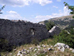
Mirandella near the ruins of the Le Forche springs |
After a virtually flat stretch, as soon as you spot (1025 m) the village of Paganico just below, leave the signs of the reserve and then follow a track of the path that turns right starting to get more decisively towards a well visible spring which can be taken as a reference. The track tends to be unclear and you'll need to make your way among the tangled vegetation to reach the fountain (943 m) after passing a metal fence. From there, coming down again and following the path of other tracks that bend to the left, you'll reach the way up path (810 m) and take left. After less than ten minutes you're back to the car. |